GPS jamming in ports can disrupt far more than vessel navigation. During a documented incident at a major U.S. container terminal, GNSS disruption affected four automated cranes for more than seven hours. Two cranes stopped operating, while two others experienced degraded performance. The source of the interference was never established, but the operational consequences were clear.
As ports increasingly rely on high-precision GNSS and Real-Time Kinematic (RTK) positioning for vessel maneuvering, automated cranes, terminal vehicles, and critical infrastructure, GPS jamming and spoofing present growing risks to operational safety and business continuity. Interference can originate from offshore sources, nearby industrial equipment, or low-cost GPS jammers carried by vehicles entering port facilities.
This article examines the scale of maritime GNSS interference, documented GPS jamming and spoofing incidents in ports, and the limitations of conventional receiver-based monitoring. It also introduces a five-layer GNSS interference monitoring architecture designed to detect threats, support source localization, and assess their impact on existing RTK positioning systems.
Maritime GPS Jamming and Spoofing: Impact on Port Operations
GNSS interference has become a widespread challenge for maritime navigation. According to GPSPATRON’s cumulative analysis of maritime GNSS interference, more than 10,000 vessels were reported affected during the second quarter of 2025, an eightfold increase over the previous quarter. More recent monitoring by Windward identified 171,286 distinct vessels affected by GPS jamming at least once during Q2 2026. Although the two studies use different methodologies and their figures are not directly comparable, both demonstrate the scale of maritime GNSS disruption.
The threat extends across major commercial shipping regions, including the Baltic Sea, Black Sea, Eastern Mediterranean, Red Sea, and Persian Gulf. However, the consequences of GPS jamming and spoofing become particularly critical when vessels approach ports, navigate narrow channels, or perform precision berthing maneuvers.
GPS Jamming Risks During Ship Maneuvering and Berthing
Modern maritime pilotage increasingly relies on high-precision GNSS positioning and specialized navigation software. Portable Pilot Units (PPUs), often equipped with Real-Time Kinematic (RTK) GNSS receivers, provide accurate real-time information about a vessel’s position, heading, speed, and movement. Solutions such as SafePilot Pro, Qastor, and Wärtsilä Pilot PRO also provide trajectory prediction and docking assistance.
These systems help pilots anticipate a vessel’s future position rather than relying solely on its current coordinates. Advanced maneuvering models can account for ship dimensions, draft, displacement, loading conditions, and environmental forces such as wind and currents. The capabilities vary between systems: some predictors extrapolate existing movement data, while more sophisticated models incorporate vessel-specific dynamics.
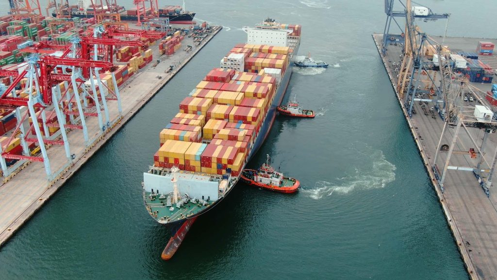
For a fully loaded container ship or LNG carrier maneuvering through a narrow harbor entrance, this information is especially valuable. Large vessels have considerable inertia, limited maneuvering space, and potentially significant wind exposure. Even at low speeds, their movement cannot be corrected instantly.
The importance of RTK positioning is demonstrated by the Panama Canal Authority, which requires vessels with a beam of 33.22 meters or more to use fixed RTK-capable piloting systems for submeter positioning accuracy.
But what happens if GNSS interference occurs during a critical berthing maneuver?
The source does not necessarily have to be a powerful military jammer. A low-cost GNSS jammer operating inside a nearby vehicle — potentially even a taxi stopped close to the waterfront — may affect receivers within its interference range. If this causes a pilot’s RTK system to lose its positioning fix, centimeter-level accuracy may degrade or become temporarily unavailable precisely when the vessel is approaching a berth or navigating confined waters.
Ships retain alternative navigation instruments and established pilotage procedures, so loss of RTK does not automatically lead to an accident. Nevertheless, sudden loss of reliable precision positioning reduces situational awareness and can increase operational risk at a critical moment.
This is not merely a hypothetical source of interference. During a 2025 shipborne GNSS monitoring campaign conducted by GPSPATRON and Gdynia Maritime University, researchers recorded repeated short-duration interference events while their vessel was berthed in the Port of Gdańsk. The signals exhibited spectral characteristics consistent with low-power automotive GNSS jammers.
How GPS Jamming Affects Port Cranes and Automated Vehicles
The consequences of GNSS interference extend far beyond vessel navigation. Modern container terminals increasingly depend on high-precision positioning to automate cargo handling and coordinate equipment movements across large operational areas.
Rubber-Tired Gantry (RTG) cranes, for example, can use GNSS-based positioning for automatic steering, container stack alignment, and integration with Terminal Operating Systems (TOS). Konecranes offers commercial systems that use GPS and differential GNSS positioning to support these functions and report container locations automatically.
If jamming disrupts the GNSS positioning system, affected cranes may lose automatic steering or positioning capabilities, requiring operators to switch to alternative operating modes or temporarily suspend automated movements. Spoofing presents a different challenge: incorrect position information may remain plausible, potentially affecting equipment guidance or cargo location reporting if not detected by independent safety systems.
Similar dependencies exist in automated terminal tractors and Automated Guided Vehicles (AGVs). Depending on their navigation architecture, these vehicles may combine RTK-GNSS with inertial sensors, LiDAR, and other positioning technologies. GNSS degradation can reduce positioning confidence, trigger safety stops, or limit autonomous operation.
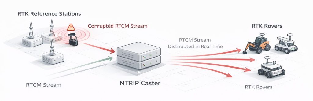
A single interference source near an RTK reference station could potentially affect multiple connected machines, creating disruptions across different parts of a terminal rather than a single isolated equipment failure.
Beyond Positioning: GNSS Timing and Connected Port Infrastructure
GNSS also provides precise time synchronization for systems that may have little apparent connection to satellite navigation.
Within ports, GNSS-disciplined time servers can support communication networks, distributed IT infrastructure, event logging, and systems requiring synchronized measurements. Where sufficient independent timing redundancy is absent, prolonged GNSS disruption or undetected spoofing may compromise synchronization accuracy, resulting in inconsistent timestamps, unreliable event correlation, or degradation of timing-dependent services.
Onboard vessels, GNSS information is distributed to multiple interconnected systems, including Electronic Chart Display and Information Systems (ECDIS), Automatic Identification Systems (AIS), integrated bridge equipment, voyage data recorders, and other applications that use satellite-derived position or time.
Consequently, a GNSS incident may affect more than the vessel’s displayed position. It can also undermine the consistency of information shared between onboard navigation systems and shore-based Vessel Traffic Services (VTS).
The actual consequences depend on system architecture, redundancy, and available backup procedures. Nevertheless, the growing integration of GNSS into port and vessel operations makes interference a wider infrastructure resilience issue, rather than an isolated navigation problem.
Why Ports Are Uniquely Vulnerable to GNSS Jamming and Spoofing
Ports operate in particularly challenging radio-frequency environments. Unlike isolated industrial facilities, they are exposed to interference originating both offshore and on land, while their extensive infrastructure creates complex signal propagation conditions. This combination makes GNSS interference difficult to predict, detect, and investigate.
Maritime and Land-Based Sources of GNSS Interference
GNSS threats can originate far beyond port boundaries. Offshore sources include military electronic warfare systems, coastal installations, and transmitters operating aboard vessels. In regions affected by military activity, high-power jamming and spoofing signals may extend across large maritime areas, potentially reaching commercial ports located considerable distances from the original source.
Land-based interference presents a different challenge. Low-cost GPS jammers used in cars and trucks to prevent vehicle tracking can unintentionally disrupt nearby GNSS equipment. Other potential sources include industrial RF emissions, malfunctioning electronic equipment, and counter-drone systems that deliberately interfere with satellite navigation frequencies.
These sources differ significantly in transmission power, coverage, duration, and signal characteristics. Some generate persistent interference affecting large areas, while others produce brief, localized disruptions as vehicles move through the port.
Importantly, the source does not need to be located inside the port or intentionally target its infrastructure to cause interference.
RF Propagation Challenges in Port Environments
Port geography further complicates GNSS interference exposure.
Open water provides unobstructed radio propagation paths. With favorable line-of-sight conditions, interference signals originating offshore can reach waterfront infrastructure with less attenuation than in densely built-up environments. GNSS antennas installed on elevated structures may be particularly exposed to distant transmitters because of their extended radio horizon.
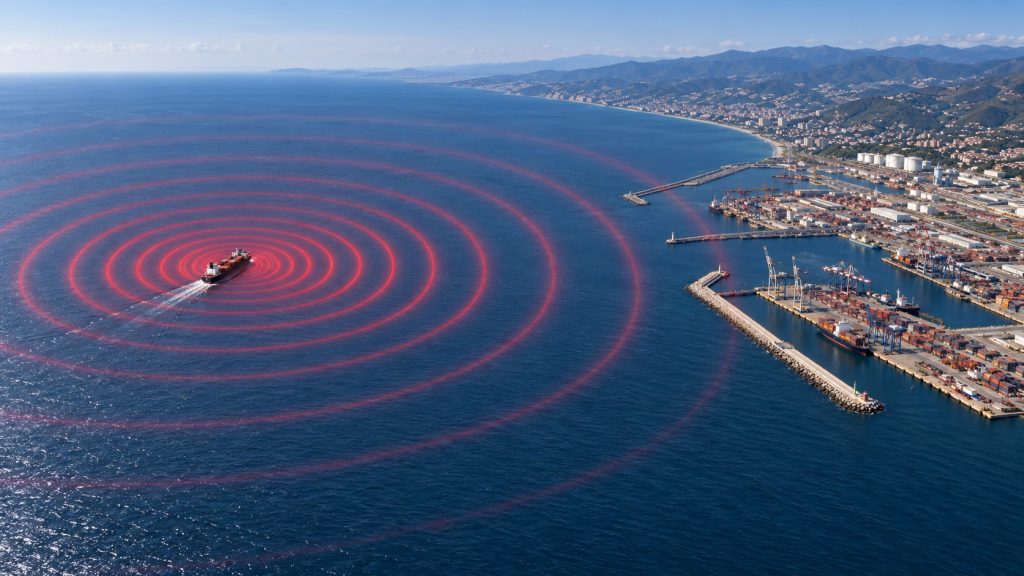
Inside container terminals, however, conditions can be dramatically different. Stacked containers, large cranes, warehouses, and other metal structures create signal shadowing and reflections. These effects can influence both legitimate satellite reception and interfering signals, producing substantial variations in GNSS signal quality across relatively short distances.
Consequently, a GNSS receiver located at a port control tower may experience entirely different interference conditions from equipment operating at a nearby quay or container yard.
This spatial variability means that measurements from a single location generally cannot provide a reliable assessment of GNSS interference throughout a large port facility.
Why Jamming and Spoofing Are Difficult to Detect in Ports
One of the greatest challenges for port operators is that GNSS interference does not always produce an obvious system failure.
Powerful jamming may cause receivers to lose satellite tracking, making the disruption immediately apparent. Lower-power interference can instead degrade signal quality without causing a complete outage. Sophisticated spoofing attacks are particularly difficult to recognize because receivers may continue reporting apparently valid positioning and timing information despite being influenced by counterfeit signals.
The temporary nature of some interference sources adds another difficulty. A moving transmitter may disrupt GNSS reception for only a few seconds before leaving the area. By the time technical personnel investigate, the signal has disappeared, leaving little information about its origin.
Conventional receiver alarms typically indicate positioning degradation or signal loss but provide limited information about the underlying RF interference. Distinguishing deliberate jamming or spoofing from equipment faults, signal obstruction, and other reception problems requires additional measurements and analysis.
Effective investigation therefore depends on more than detecting an abnormal GNSS position. It requires understanding when and where interference occurred, its RF characteristics, how it affected signal quality, and whether multiple monitoring locations observed the same event.
These challenges raise an important question: how often do such interference events occur in real port environments, and what can documented incidents tell us about their causes and operational consequences?
Real GPS Jamming and Spoofing Incidents in Ports
The operational consequences of GNSS interference are supported by documented incidents involving container terminals, commercial vessels, and maritime authorities. These cases demonstrate that disruptions can range from localized equipment failures to widespread navigational uncertainty and restrictions on maritime activity.
United States: GPS Interference Disrupts Container Crane Operations
One of the clearest examples of GNSS interference directly affecting cargo handling occurred at a major container terminal on the U.S. East Coast.
According to the U.S. Department of Homeland Security, a GPS anomaly in 2013 affected four automated cranes for more than seven hours. Two cranes stopped operating after losing positioning information, while the performance of two others was degraded.
The incident was subsequently described by a U.S. Coast Guard representative during a public meeting on maritime cybersecurity in January 2015. The facility was not identified, and the source and intent of the interference were not established.
This case demonstrates that the loss of GNSS positioning can directly interrupt commercial port operations, even without physical damage to equipment or a conventional cybersecurity breach.
Port of Shanghai, China: GPS Spoofing Disrupts Vessel Navigation
In July 2019, the U.S.-flagged container ship Manukai encountered serious GPS anomalies while navigating the Huangpu River and approaching its berth in Shanghai.
According to a report submitted to the U.S. Coast Guard, nearby vessels appeared to move through the channel on the ship’s Electronic Chart Display and Information System (ECDIS), even though they were actually stationary at their berths. During the final maneuver, both onboard GPS receivers repeatedly lost positioning signals, triggering alarms across interconnected navigation equipment.
A subsequent investigation by C4ADS and SkyTruth revealed that the incident was part of a much larger pattern. Analysis of vessel tracking data identified systematic GPS manipulation at at least 20 coastal locations in China, predominantly around oil terminals.
Affected vessels appeared to jump from their actual positions to false coordinates on land, often forming distinctive circular patterns approximately 200 meters in diameter. Some reported impossible speeds of 21 or 31 knots while operating near port facilities.
The findings demonstrated that GNSS spoofing could affect multiple vessels simultaneously in heavily trafficked waterways, making it difficult for bridge teams to distinguish legitimate navigation information from corrupted positioning data.
Qatar, October 2025: GPS Disruption Leads to Maritime Navigation Restrictions
On October 4, 2025, Qatar’s Ministry of Transport announced the temporary suspension of maritime navigation activities following the discovery of a GPS malfunction that could compromise the accuracy of marine navigation equipment.
The restrictions were introduced as a precautionary safety measure. Partial navigation resumed on October 6 under specific operating conditions, and the ministry announced the full resumption of maritime navigation activities on October 9.
Although the official announcements did not establish the precise technical cause of the GPS malfunction or quantify its economic impact, the incident demonstrates a significant operational consequence: GNSS reliability concerns can be serious enough for maritime authorities to restrict vessel movements.
Los Angeles Harbor, July 2025: Repeated GPS Jamming at Yusen Container Terminal
Between July 13 and 24, 2025, at least 48 separate GPS jamming events were reported at Yusen Container Terminal in the Port of Los Angeles, California, according to the U.S. Coast Guard’s GPS User Issue Detection and Evaluation (GUIDE) database.
The interference was strong enough to cause Northstar GNSS receivers to lose acquisition and tracking of all GPS satellites. Individual events lasted just under four minutes on average and frequently occurred at four-hour intervals, indicating a recurring interference pattern.
The U.S. Coast Guard’s GPS Operations Center found no known satellite system anomalies, significant space weather effects, or authorized GPS testing that could explain the disruptions. The case was classified as Unknown Interference, with the source remaining unidentified.
This incident demonstrates how repeated, short-duration GNSS interference can occur directly within a commercial container terminal. Although no disruption to cargo-handling operations was documented, the complete loss of satellite tracking highlights the importance of continuous GPS jamming detection and interference monitoring in port environments.
For port operators, detecting interference is only the first step. The next challenge is determining whether existing GNSS protection technologies can provide reliable signal integrity and sufficient operational awareness under these conditions.
GNSS Interference Monitoring for Ports: Five-Layer Architecture
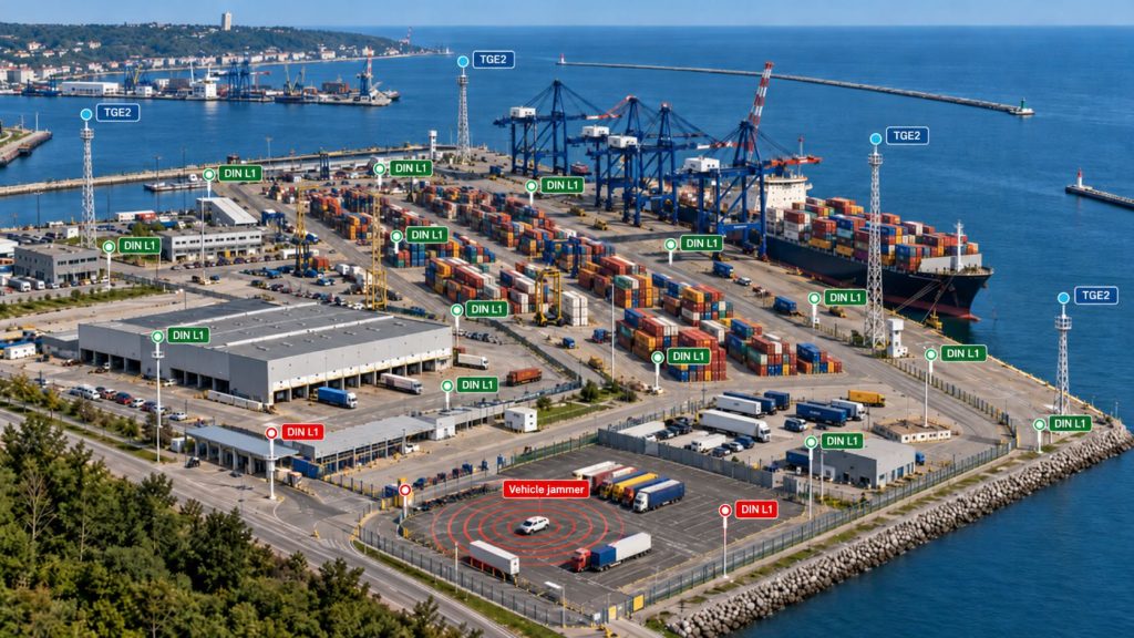
The incidents described above demonstrate that no single GNSS detector can address every threat faced by a modern port. Powerful offshore jamming, sophisticated spoofing attacks, low-power vehicle jammers, and industrial interference require different detection and response strategies.
GPSPATRON proposes a five-layer monitoring architecture combining advanced RF analysis, distributed interference detection, mobile field response, and direct monitoring of existing RTK positioning infrastructure.
Layer 1: Advanced Detection and Forensic Analysis — GP-Probe TGE2

Target threats: High-power regional and military-grade interference, deliberate spoofing attacks, and sophisticated GNSS signal manipulation.
Several GP-Probe TGE2 sensors deployed at strategic locations provide continuous GNSS signal analysis, including sophisticated coherent spoofing detection and RF spectrum analisys. With TDOA capabilities, a distributed network can also estimate the locations of interference sources.
Objective: Detect sophisticated threats, distinguish jamming from spoofing, identify affected GNSS signals, and collect forensic evidence for technical investigation.
Layer 2: Local Interference Detection and Vehicle Identification — GP-Probe DIN L1
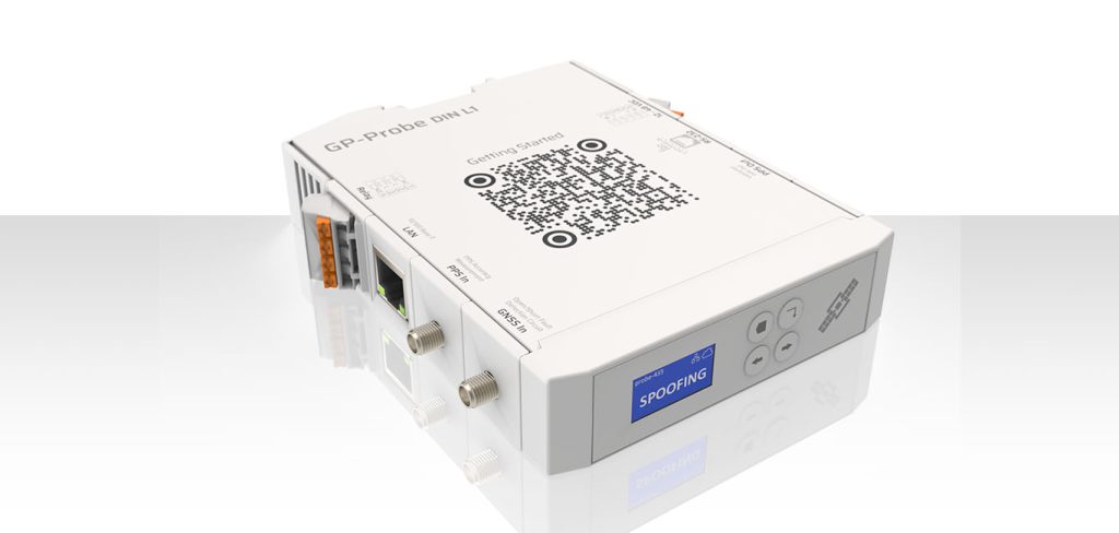
Target threats: Low-power automotive GPS jammers, localized industrial interference, and unauthorized GNSS transmissions within the port.
A dense network of GP-Probe DIN L1 sensors deployed along access roads, terminal gates, container yards, and quays provides continuous local monitoring. Correlating interference measurements across sensors helps narrow down affected areas and identify recurring sources.
Integration with CCTV, automatic number plate recognition (ANPR), and gate management systems can trigger camera recording and associate detected interference events with passing vehicles.
Objective: Detect and help identify localized interference sources, particularly vehicle-mounted GPS jammers, before they repeatedly disrupt port operations.
Layer 3: Rapid On-Site Investigation and Response — GP-Probe Nano L1

Target threats: Interference sources requiring physical identification and immediate intervention.
Port security teams equipped with several dozen portable GP-Probe Nano L1 detectors can investigate alerts from the fixed monitoring network. Using real-time signal strength indicators, officers can approach suspected vehicles or equipment and identify the source at close range.
Once located, authorized personnel can request or arrange for the interfering device to be switched off and verify that the interference has disappeared.
Objective: Turn remote interference alerts into actionable field investigations and rapid removal of identified sources.
Layer 4: RTK Reference Station Monitoring via RTCM/NTRIP
Target systems: Existing RTK base stations supplying precision positioning corrections to port equipment and maritime pilotage systems.
GP-Cloud can connect directly to existing RTK reference stations through RTCM/NTRIP data streams, without replacing their GNSS receivers.
Continuous analysis of satellite observations, signal quality, and correction data helps identify anomalies affecting the reference station and the reliability of its output.
Objective: Determine whether GNSS interference is affecting the RTK reference infrastructure and potentially compromising the correction data distributed to dependent receivers.
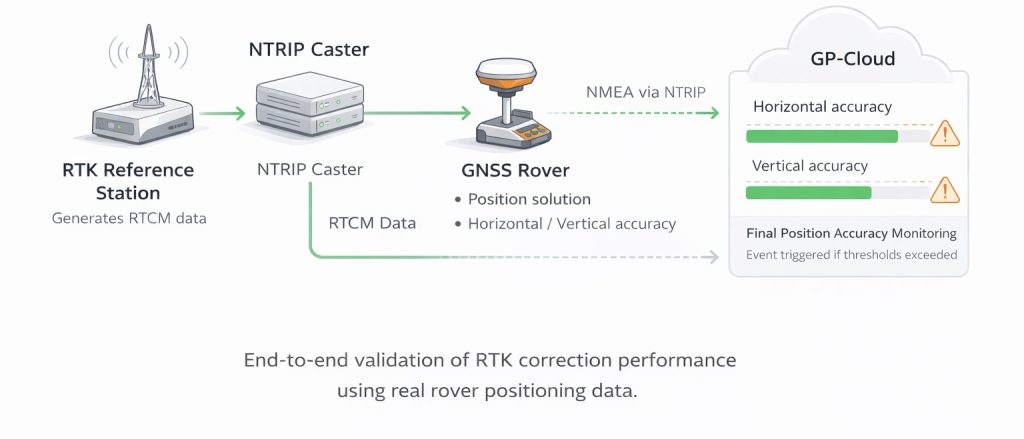
Layer 5: RTK Rover Positioning Performance Validation
Target systems: RTK rovers and precision navigation equipment used for vessel maneuvering and berthing.
As a final validation layer, an existing RTK rover can be connected to the port’s operational reference station to continuously monitor positioning performance, RTK fix availability, reported accuracy, and velocity measurements.
A rover installed at a precisely surveyed reference point enables direct measurement of positioning errors. Monitoring an operational pilotage rover provides additional insight into real-world navigation performance; independently verifying accuracy while the vessel is moving requires an independent position and velocity reference.
Objective: Measure the actual degradation of RTK positioning performance, rather than relying solely on the detection of RF interference or anomalies in reference station data.
This final layer helps port operators distinguish between detected GNSS interference and its measurable consequences for RTK positioning. By comparing rover measurements against a surveyed reference position, the system can identify actual positioning errors, RTK fix degradation, and changes in reported velocity or accuracy.
Centralized Port GNSS Monitoring with GP-Cloud
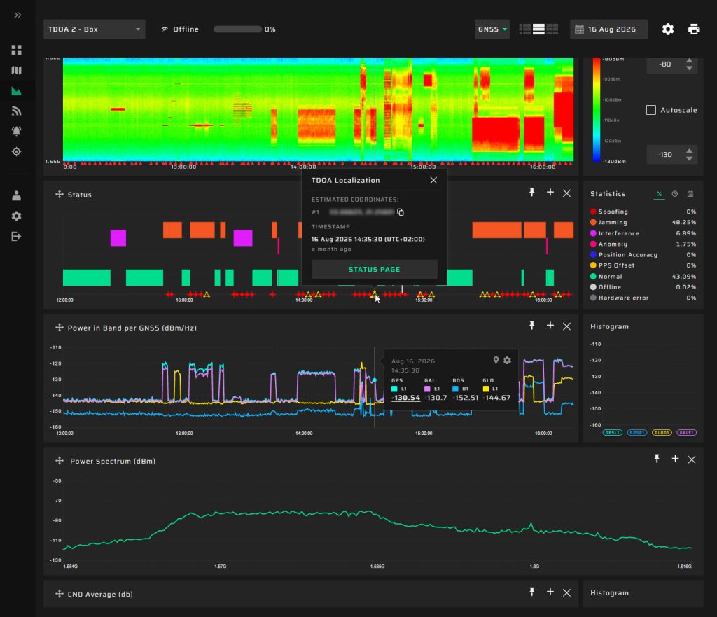
All five layers are brought together through GP-Cloud, providing real-time alerts, interference maps, historical records, and correlated analysis of GNSS threats and their operational impact.
The result is a comprehensive approach covering the entire response chain:
Detect the threat → Classify and localize the source → Investigate and respond → Verify RTK integrity → Measure actual positioning performance.
This architecture enables port operators not only to understand where GNSS interference is occurring, but also to determine whether it is affecting the systems responsible for safe and efficient port operations.
Assess GNSS Interference Risks at Your Port
Every port has a unique GNSS environment, operational infrastructure, and exposure to interference. An effective monitoring strategy should reflect these differences rather than rely on a one-size-fits-all deployment.
GPSPATRON works with port authorities and terminal operators to assess GNSS vulnerabilities, identify critical monitoring locations, and design monitoring architectures tailored to their operations.
A pilot deployment can help establish actual interference conditions, evaluate the integrity of existing RTK infrastructure, and determine the appropriate combination of fixed and portable detectors.
Want to understand how GPS jamming and spoofing could affect your port?
Contact GPSPATRON to discuss your infrastructure and explore a pilot monitoring project.
Enter your details and we will send the download link to your email.