

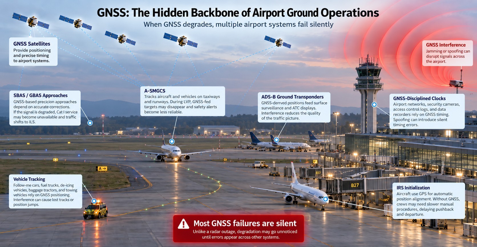
GNSS interference at airports is a blind spot. Most airport administrators assume it is only a concern for aircraft at cruising altitude or during SBAS/GBAS approaches. Since almost every airport has ILS for landing, the reasoning goes, GNSS disruption is a pilot’s problem, not an airport’s problem. That assumption is wrong. Dozens of airport systems depend on GNSS for positioning, timing, or both, and most of them operate on the ground:
- A-SMGCS surface surveillance,
- vehicle tracking,
- pushback and towing guidance,
- IRS initialization,
- “Follow the Greens” taxiway lighting,
- ADS-B ground transponders,
- and GNSS-disciplined clocks that synchronize communications and security networks.
When interference occurs, these systems degrade silently. The airport has no alert, no log, and no way to know it happened, because there is no detection system in place. GPS signal loss events affecting aviation increased 220% between 2021 and 2024, according to IATA’s Global Aviation Data Management program. In 2025, more than 1,000 GNSS interference incidents were recorded worldwide every day. The question is not whether airports are affected. It is whether they can see it.
For approach and landing, aircraft can rely on RNAV and RNP procedures. But on the airport surface, during low-visibility procedures (LVP), GNSS is the primary positioning source for taxiing, pushback, A-SMGCS surveillance, towing, and vehicle tracking. There is no equivalent ground backup. Monitoring also plays a role in security: at Warsaw’s Chopin Airport, a deliberate jammer was used near the airfield. Ground-based detection can identify and help localize such intentional threats before they escalate.

Where Does Airport GNSS Interference Come From?
Airports sit at the intersection of multiple interference sources, many of which are not obvious or intentional:
- Counter-drone systems are an increasingly important source of interference around airports. These systems often use powerful RF jamming to disrupt drone navigation and control links, but their effects can extend beyond the intended target. In 2025, U.S. government counter-drone testing near Reagan Washington National Airport interfered with aircraft collision-warning systems, affecting at least a dozen flights and causing several crews to abort landings and perform go-arounds. In another case, counter-drone testing led to the temporary closure of El Paso International Airport. Similar effects have been observed in drone operations: during a 600-drone show in Budva, Montenegro, GNSS interference caused multiple aircraft to lose navigation, collide, and fall into the sea.
- Military electronic warfare exercises also generate interference. Armed forces routinely use GNSS jamming and spoofing during training, and civilian aviation can be affected when exercises occur near airports or flight routes. In May 2026, a Beechcraft King Air C90 air ambulance crashed in New Mexico during an active U.S. military GPS-jamming exercise. The crew had reported loss of GPS, and other aircraft in the area experienced similar outages. The NTSB investigation is still ongoing and has not yet established whether the jamming contributed to the crash.
AP — Military jamming disrupted a medical plane’s GPS system before it crashed - Vehicles carrying personal jammers create a constant, low-level background of interference around airports. Taxi drivers, truck drivers, and delivery vehicles sometimes use cheap GPS jammers to avoid fleet tracking. At Newark Liberty International Airport, a single $68 car jammer repeatedly disrupted a multimillion-dollar GBAS precision landing system between 2009 and 2012.
- Maritime sources of interference can also pose a risk to coastal airports. During a six-month monitoring campaign on the Baltic coast near Gdańsk, GPSPATRON and Gdynia Maritime University recorded 84 hours of GNSS interference. Analysis of recurring signal patterns and their movement indicated that the source was likely a jammer installed on one or more vessels operating in the Baltic Sea. Mobile maritime interference can travel along shipping routes and potentially affect GNSS-dependent infrastructure as vessels approach coastal areas.
- Deliberate interference as part of sabotage or criminal activity is a growing concern. In August 2026, Bulgarian authorities located a powerful GPS jammer in Sofia that was affecting the capital, Sofia Airport, and aircraft flying overhead. Police seized an SUV containing elements of a professional jamming system, and the investigation later identified two separate jammer systems. A similar security incident occurred at Warsaw’s Chopin Airport, where a suspect was arrested for operating a GNSS jammer near the airfield.
- BTA — Investigation, searches and seizures in GPS jammer case
- Industrial noise from nearby equipment, transmitters, or construction sites can also cause unintentional interference on GNSS frequencies, degrading signal quality without any malicious intent.
Airport Systems That Depend on GNSS and How Interference Affects Them
Many airport operators underestimate how deeply GNSS is embedded in their ground infrastructure. The following systems rely on GNSS signals for positioning, timing, or both:
- A-SMGCS (Advanced Surface Movement Guidance and Control System) uses GNSS as a cooperative surveillance input. During low-visibility procedures, it tracks aircraft and vehicles on taxiways and runways. When GNSS fails, vehicles tracked solely by GNSS vanish from the surveillance picture, and safety alerts like runway incursion warnings (RMCA) lose accuracy.
- Vehicle tracking systems for follow-me cars, fuel trucks, de-icing vehicles, baggage tractors, and towing vehicles rely on GNSS positioning. Interference can cause position jumps, lost tracks, or incorrect locations displayed to controllers.
- IRS initialization on aircraft uses GPS for automatic position alignment. Without GNSS, crews must revert to slower manual alignment procedures, causing pushback and departure delays.
- SBAS/GBAS Cat I precision approaches depend entirely on GNSS. If interference degrades the ground station’s ability to generate corrections, the approach becomes unavailable and aircraft must use ILS instead, reducing capacity.
- GNSS-disciplined clocks synchronize airport communications networks, security camera systems, access control logs, and data recording systems. Spoofing can introduce timing errors that propagate through these networks silently.
- ADS-B ground transponders include GNSS-derived positions in their broadcasts. Interference degrades the quality of surface surveillance data fed into A-SMGCS and ATC displays.
- CPDLC (Controller-Pilot Data Link Communications) provides textual air traffic control communication, while GNSS (Global Navigation Satellite System) supplies the highly accurate time reference and aircraft position data necessary for the surveillance and navigation systems that support data link operations.
The critical point is that most of these failures are silent. Unlike a radar outage, which triggers an immediate alarm, GNSS degradation often goes unnoticed until its consequences appear in other systems. Without dedicated monitoring, the airport has no way to correlate a vehicle tracking anomaly with an interference event that lasted 30 seconds on a perimeter road.
The Hidden Danger: GNSS Disruption During Low-Visibility Surface Operations
The most severe consequences of GPS jamming and spoofing at airports are not limited to approach and landing. They occur on the ground, especially during low-visibility procedures (LVPs), when pilots and controllers lose visual references and depend heavily on instrumented systems. During these conditions, GNSS supports taxiing (aircraft on the ground have essentially no alternative to GNSS for precise position awareness), pushback guidance, IRS initialization and position alignment, towing operations, A-SMGCS surveillance for surface movement tracking, and movement of all vehicles and aircraft on the maneuvering area.
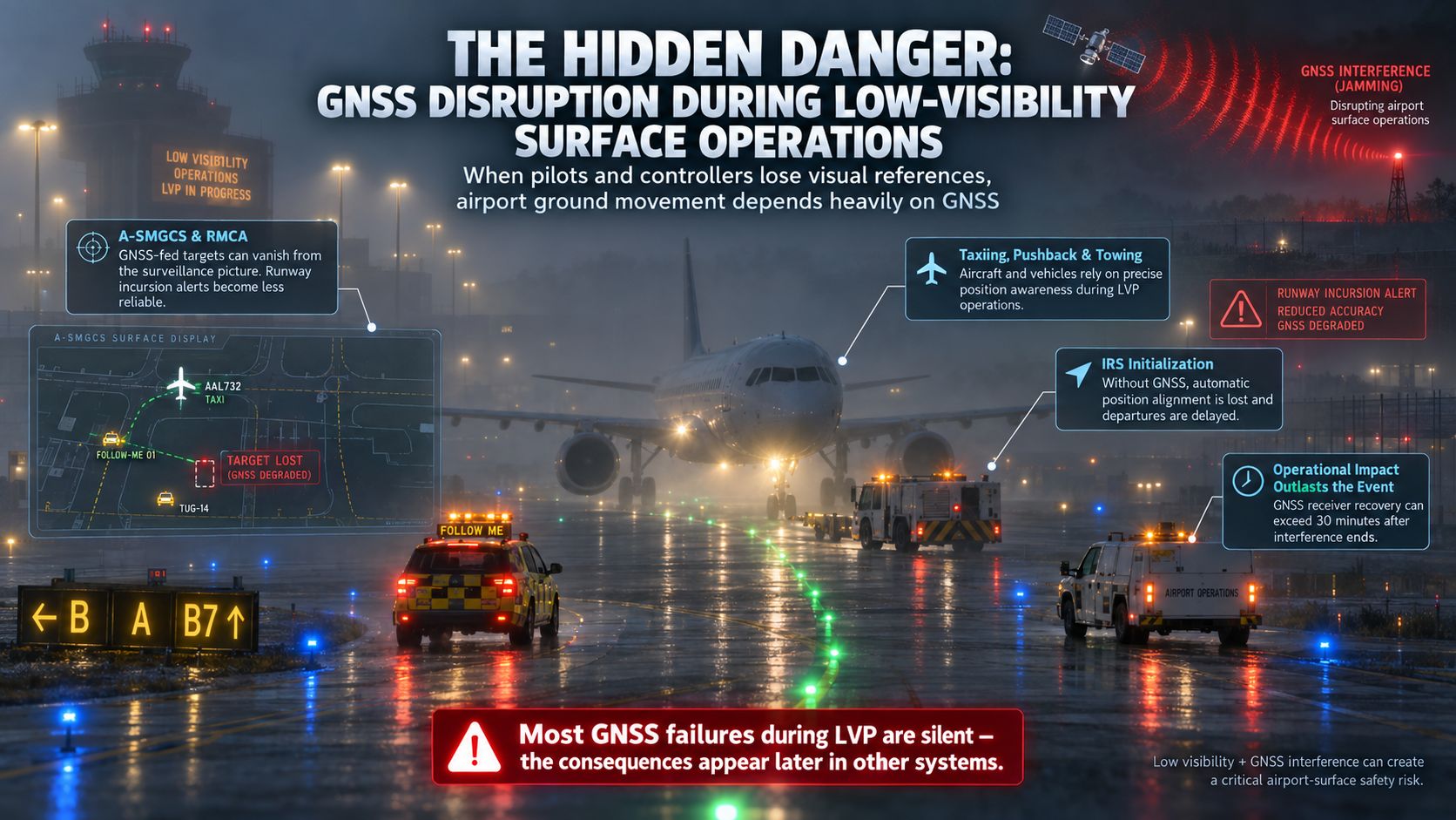
When GNSS fails during LVPs, A-SMGCS degrades because vehicles tracked solely by GNSS vanish from the surveillance picture. Safety nets like runway incursion alerting (RMCA) lose accuracy at precisely the moment when visual detection is impossible.
The IATA Safety Risk Assessment notes that GNSS receiver recovery time can exceed 30 minutes after interference ends, meaning the operational impact outlasts the interference event itself. The December 2024 crash of Azerbaijan Airlines Flight 8243 near Grozny, where GPS jamming and spoofing in a conflict zone contributed to navigation failure in deteriorating weather and resulted in 38 fatalities, remains the most tragic illustration of what happens when GNSS interference meets low visibility without adequate monitoring.
Why Current Detection and Protection Approaches Fall Short
Most airports today rely on pilot reports (PIREPs) as their primary method for identifying GNSS interference. This approach has fundamental limitations. A EUROCONTROL study comparing ADS-B/MLAT detection data with pilot reports found that only 2 to 10% of actual interference events are formally reported, and as pilots get used, statistics are going down. During the 2022 Denver International Airport jamming event, Stanford University’s ADS-B-based algorithm detected interference more than one hour before the first pilot report. PIREPs provide no precise location, no signal classification, and no continuous monitoring. So what is GPS jamming detection supposed to look like? It requires automated, ground-based sensors capable of 24/7 operation, not human reporting chains.
Beyond reporting, several protection technologies exist but each has limits for airport-wide scenarios. CRPA (Controlled Reception Pattern Antennas) provide GPS anti-jamming capability for individual receivers by nulling interference signals, but they protect only a single point and do not provide situational awareness across the airport. Multi-band multi-constellation GNSS receivers offer improved resilience against narrowband interference but remain vulnerable to wideband jamming and sophisticated spoofing. None of these methods tell the airport operator where the interference is coming from, what type of signal it is, how strong it is, or whether it is recurring. They protect individual systems; they do not protect the airport as a whole.
The Multi-Layer Architecture: From GNSS Interference Monitoring to Operational Response
An airport is a uniquely complex piece of infrastructure. As the previous sections show, it combines numerous systems that depend on GNSS with a wide variety of interference sources, from uncontrolled anti-drone jammers to vehicle-borne PPDs to distant military operations. No single sensor can cover this range of threats across the entire airport footprint. The approach must be multi-layered: different sensor types at different locations, each serving a specific detection role, connected through a centralized platform that enables classification, localization, correlation with operations, and incident documentation.
Layer 1: Strategic Advanced Sensors (GP-Probe TGE2)

The first layer consists of approximately four GP-Probe TGE2 units strategically installed around the airport perimeter and critical zones. Each TGE2 is a three-channel detector with spatial analysis, a 60 MHz spectrograph, and coherent GPS/GNSS spoofing detection capability. These sensors detect and classify stronger or more complex threats, provide advanced signal analysis including spectral fingerprinting, support localization of high-power or sophisticated emitters through multi-sensor TDOA (Time Difference of Arrival) calculations, and identify possible military-grade or advanced interference sources. With four TGE2 sensors, the airport gains area-wide visibility and the geometric baseline needed for localization logic. The expected accuracy for a source within the sensor network is 100 to 200 meters, enough to direct a response team to a specific road segment, parking area, or building.
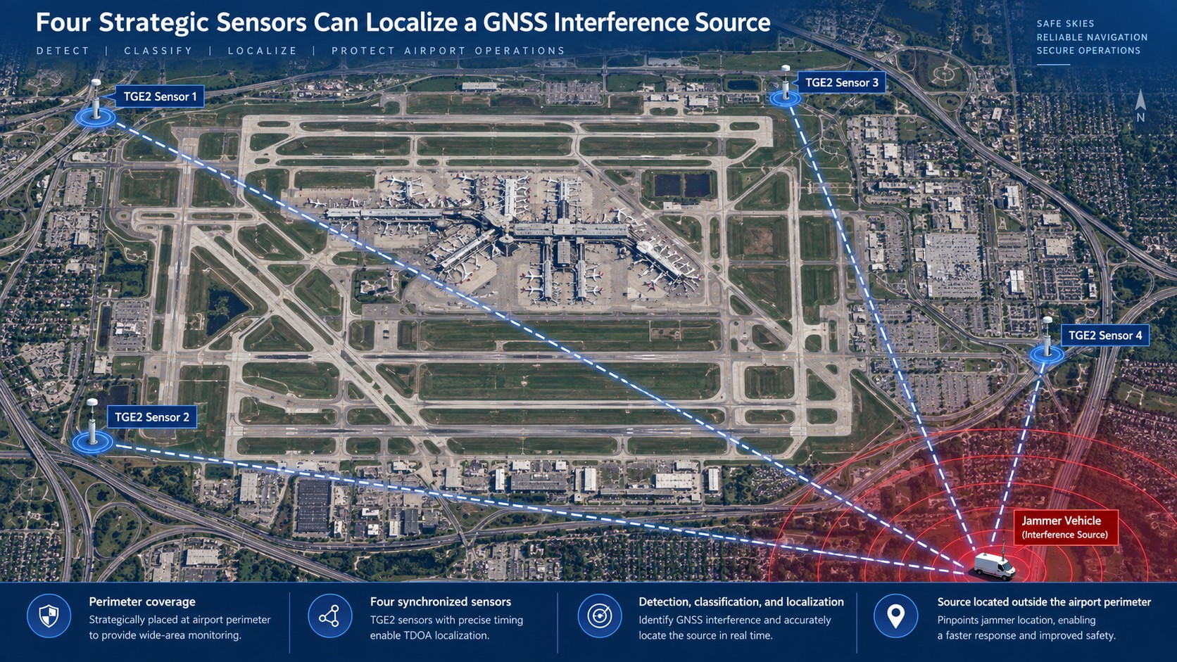
In summary, these sensors are primarily intended to detect and localize high-power interference sources originating outside the airport perimeter. For this reason, their antennas should be installed on tall masts or elevated building rooftops to ensure a clear radio horizon and enable long-range localization. In addition, the GP-Probe TGE2 is capable of detecting sophisticated spoofing scenarios that may not be visible to simpler monitoring devices.
Layer 2: Dense Local Coverage for Weak and Localized Interference (GP-Probe DIN L1)
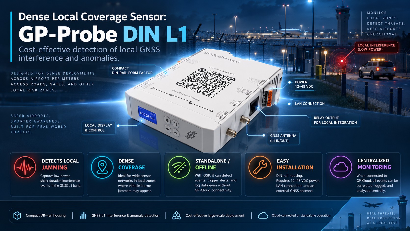
Not all interference is powerful enough to reach the strategic TGE2 sensors installed around the airport perimeter. Low-power vehicle jammers and other localized sources may be heavily attenuated by terminal buildings, hangars, terrain, and other obstacles. As a result, interference may significantly affect GNSS within a small operational area—such as a taxiway, gate, service road, or aircraft towing route during low visibility—while remaining completely invisible to sensors located farther away.
To close these coverage gaps, the second layer uses 20–40 GP-Probe DIN L1 sensors distributed across critical airport zones, perimeter roads, access points, parking areas, and other locations where localized interference is most likely. Dense coverage makes it possible to detect short-lived and low-power events and identify the specific area where they occur, including vehicle-borne jammers active for only tens of seconds.
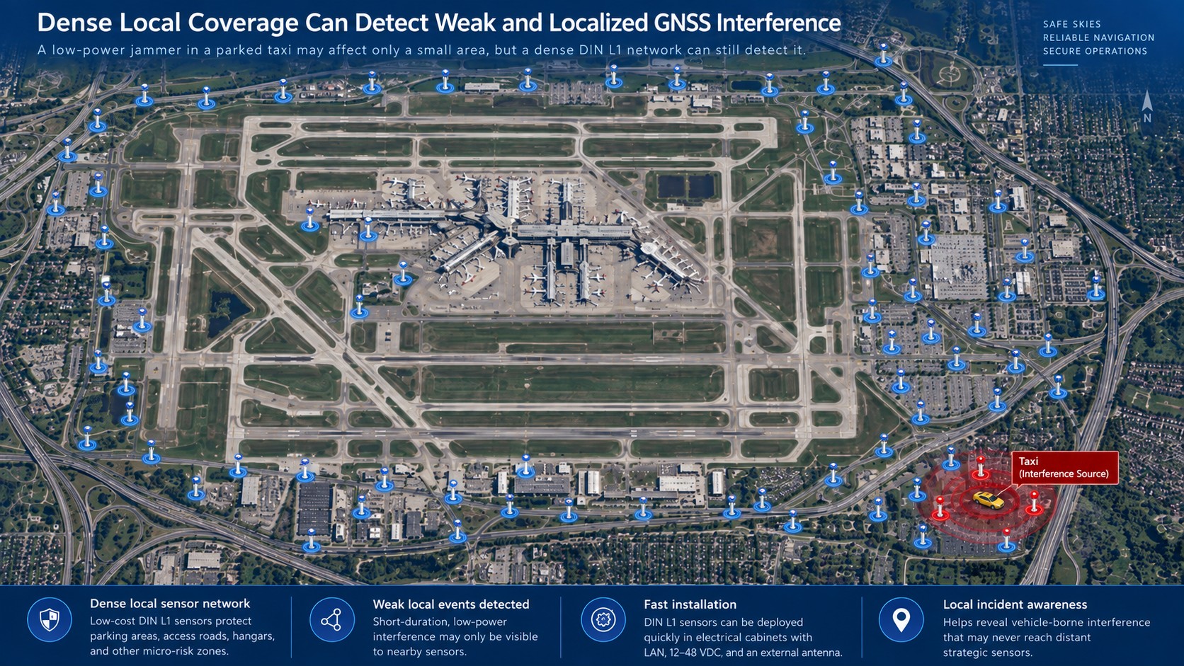
The DIN L1 is designed for cost-effective large-scale deployment. Its DIN-rail form factor allows installation inside existing electrical cabinets; typically, only 12–48 VDC power, LAN connectivity, and an external GNSS antenna are required. This makes it practical to create a dense detection mesh without the cost and installation complexity of deploying advanced TGE2 sensors at every location.
With the OSP option, DIN L1 can also operate independently of GP-Cloud, detecting interference and anomalies locally when connectivity is unavailable. When connected to GP-Cloud, events from the entire sensor network can be centrally correlated, logged, and analyzed. DIN L1 is intended primarily for detecting localized L1-band interference and GNSS anomalies; advanced spectral analysis, sophisticated spoofing detection, and long-range TDOA localization remain the role of the TGE2 sensors in Layer 1.
Layer 3: Camera Correlation and Operational Response (GP-Cloud)
Detection and localization data from Layers 1 and 2 become significantly more actionable when correlated with video systems, gate logs, and access control data. GP-Cloud provides the centralized analysis platform for this correlation through its API integration capabilities and real-time event mapping. When a DIN L1 sensor on an access road detects a recurring interference pattern every weekday at 7:15 AM, GP-Cloud logs the exact timing and signal strength profile. The airport security team can then cross-reference this with CCTV footage from that road segment to identify the specific vehicle.
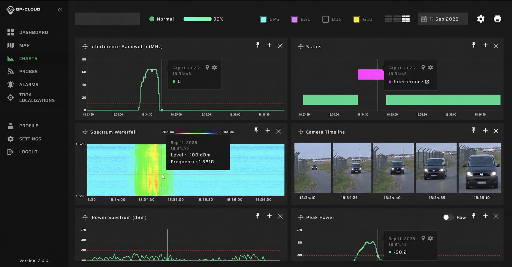
This is important because low-power mobile jammers may otherwise remain extremely difficult to identify. The interference event lasts seconds, affects a limited area, and leaves no trace unless a sensor was recording at that exact location and time. GP-Cloud correlates GNSS interference events detected by the probes (jamming, spoofing, signal anomalies). It does not directly analyze CCTV feeds or access control systems. The correlation is achieved by matching timestamped interference data from GP-Cloud with timestamped records from the airport’s existing video and access systems.
Layer 4: Rapid Last-Meter Response (GP-Probe Nano L1)

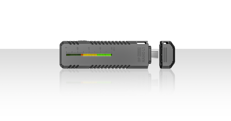
The final layer equips field personnel with portable detection tools for source confirmation and intervention. The GP-Probe Nano L1 is a pocket-sized GNSS interference detector with vibration, sound, and LED alerts. It provides 30 days of battery life in detector mode and up to 3 months in logger mode, and connects to an Android app via USB-C for on-screen signal visualization. This is a rapid response layer, not a primary detection layer. Once the fixed network narrows a threat to a parking lot, a gate, or a road segment, a security officer with a Nano L1 can walk the area and confirm the exact source through increasing signal strength indications.
Real-Time GNSS Interference Detection
Compact wearable detector monitoring L1 band activity and triggering instant alerts on jamming events, enabling immediate operational response.
Measurable Operational Outcomes
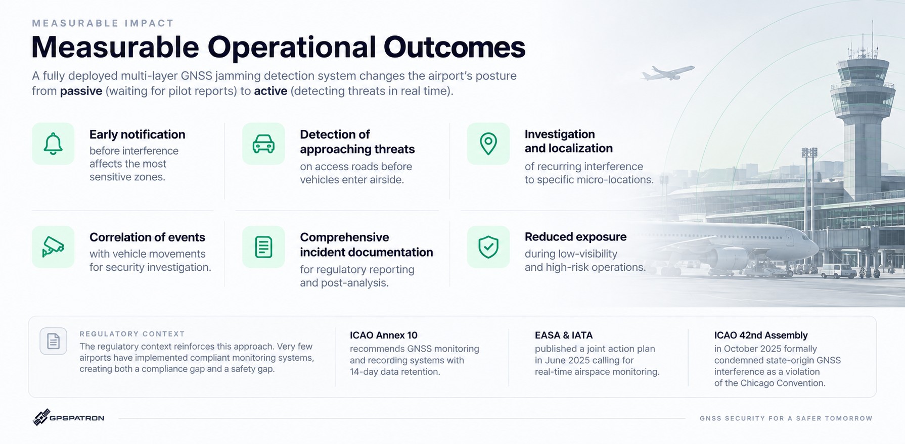
A fully deployed multi-layer GNSS jamming detection system changes the airport’s posture from passive (waiting for pilot reports) to active (detecting threats in real time). Specific outcomes include:
- early notification before interference affects the most sensitive zones,
- detection of approaching threats on access roads before vehicles enter airside,
- investigation and localization of recurring interference to specific micro-locations,
- correlation of events with vehicle movements for security investigation,
- comprehensive incident documentation for regulatory reporting and post-analysis,
- and reduced exposure during low-visibility and high-risk operations.
The regulatory context reinforces this approach. ICAO Annex 10 recommends GNSS monitoring and recording systems with 14-day data retention. EASA and IATA published a joint action plan in June 2025 calling for real-time airspace monitoring. The ICAO 42nd Assembly in October 2025 formally condemned state-origin GNSS interference as a violation of the Chicago Convention. Very few airports have implemented compliant monitoring systems, creating both a compliance gap and a safety gap.
Capabilities and Limitations: An Honest Assessment
This architecture is a monitoring, detection, classification, and logging system. It does not block, suppress, or neutralize jamming or spoofing signals. What the system provides is the intelligence layer that makes every other response (dispatching security, filing regulatory reports, alerting ATC, adjusting procedures) faster, better informed, and evidence-based.
Specific limitations to understand: the DIN L1 sensors cannot perform spectral analysis or coherent spoofing detection; the TGE2 sensors are needed for those capabilities. The TGE2 requires GP-Cloud connectivity to operate and cannot function in standalone mode, meaning network reliability at each installation point is a planning consideration. Localization accuracy depends on sensor geometry and the number of TGE2 units with line-of-sight to the source. GP-Cloud correlates GNSS RF interference events detected by the probes or another GNSS receivers. For airports considering a phased approach, even a minimal deployment of several DIN L1 sensors at key locations provides immediate value through automated logging and alerting, with the option to expand to full multi-layer coverage over time.
Getting Started: From Assessment to Deployment
Implementing a multi-layer GNSS interference monitoring system does not require a single large-scale project. A practical starting point is an assessment phase using a small number of DIN L1 sensors at known risk points (perimeter roads, approach corridors, parking areas) to establish a baseline of actual interference activity. Many airports are surprised by the frequency and variety of events they discover. From there, the deployment can expand based on observed data: adding TGE2 sensors where localization capability is needed, extending DIN L1 coverage to gaps identified by initial monitoring, and integrating GP-Cloud event logs with existing security and operations workflows.
Such assessment can be performed as-a-service in a relatively very short time. Imagine, just only one month, from order to full awareness.
Just one month is sufficient to build comprehensive situational awareness of activities occurring in the vicinity of an airport. Based on our experience, the initial analysis of actual anomalies is the critical first step toward engaging cooperating organizations, including ANSPs, CAAs, country frequency authorities, national security services, and others, in a rigorous and committed approach to the subject matter.
This serves as a key trigger that will enable the protection of critical infrastructure well into the future. Do not delay. Become aware of what is happening around you.
Contact GPSPATRON to discuss a tailored multi-layer GNSS interference monitoring architecture for your airport.
Enter your details and we will send the download link to your email.


