

Recently, colleagues operating European RTK infrastructure contacted us regarding an unusual GNSS interference event and asked us to check whether the same event was visible in our distributed monitoring network. According to their observations, the event occurred at approximately 09:10 UTC on 3 September 2026 and caused a noticeable degradation in GNSS signal quality across multiple RTK stations.
Following their request, we reviewed historical data from the GPSPATRON distributed monitoring network. Our analysis confirmed that a short-duration interference event had indeed occurred at the same time and had been detected by our sensors across a very wide geographic area — from Poland to the United Kingdom.
Our system detected the event on multiple independent sensors and automatically classified it as jamming affecting GPS and Galileo. The interference was clearly visible in the RF domain, and on our monitoring points it was accompanied by a drop in C/N₀ of approximately 2 to 5 dB-Hz for GPS and Galileo signals.
Detected by GPSPATRON Sensors and GP-Cloud Across Europe
The same interference was recorded by multiple independent GNSS data sources and sensor types within the GPSPATRON monitoring infrastructure. These included RTK reference stations connected via RTCM@NTRIP, Septentrio receivers connected via SBF@NTRIP, GP-Probe DIN L1, and GP-Probe TGE2 interference detectors.
This cross-platform consistency is important because the devices differ in RF front ends, GNSS receivers, antennas, installation environments, and data-processing methods. Nevertheless, they all showed the same short disturbance at the same time. GP-Cloud automatically detected the RF anomaly and classified it as jamming affecting GPS and Galileo.
Across the affected monitoring points, the event produced a measurable reduction in carrier-to-noise density, with C/N₀ decreasing by approximately 2 to 5 dB-Hz depending on the receiver and location.
Event Overview
| Parameter | Observation |
|---|---|
| Date | 3 September 2026 |
| Approximate time | Around 09:10 UTC |
| Event duration | A few seconds |
| Geographic coverage | Across Europe, from Poland to the United Kingdom |
| Sensor types | RTK stations, Septentrio receivers, GP-Probe DIN L1, GP-Probe TGE2 |
| GNSS affected | GPS and Galileo |
| Automatic classification | Jamming |
| Observed C/N₀ degradation | Approximately 2–5 dB-Hz |
| RF signature | Short-duration broadband interference |
Figure 1 shows how the event appeared on one of the GPSPATRON monitoring points:
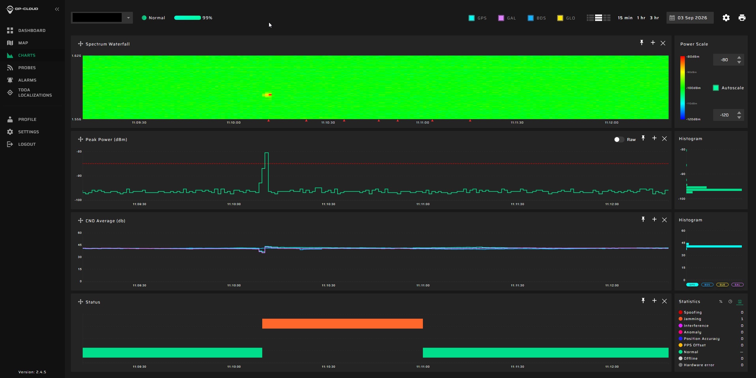
The upper Spectrum Waterfall shows a short RF emission appearing suddenly in the GNSS L1/E1 band. At the same moment, the Peak Power graph records a sharp increase in received RF power. The C/N₀ Average graph below shows a corresponding degradation in GPS and Galileo signal quality. The lower status timeline shows that GP-Cloud automatically recognized the disturbance and created a Jamming event. Although the RF emission itself lasted only a few seconds, the effect is clearly distinguishable from the surrounding normal RF environment.
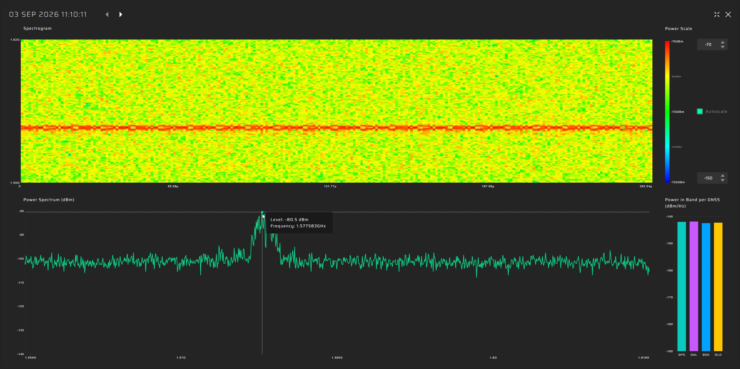
GP-Probe TGE2 automatically triggered an RF IQ capture, allowing GP-Cloud to preserve both the spectrogram and power spectrum for post-event analysis:
RF Signal Characteristics
| Parameter | Observation |
|---|---|
| Approximate peak frequency | ~1577.5 MHz |
| Approximate bandwidth @ -10 dB | ~2.46 MHz |
| Signal structure | Broadband, modulated |
A Known Space-Based GNSS Interference Phenomenon
The event observed by GPSPATRON on 3 September 2026 closely matches a phenomenon already described in several scientific studies. Published measurements report short-duration interference around 1577.5 MHz, lasting only a few seconds and causing simultaneous C/N₀ degradation across widely separated GNSS stations.
The most relevant publications are:
- Clements & Humphreys – “Transient Space-Based GNSS Interference: Observations and Analysis,” ION GNSS+ 2025 – documented transient wide-area GNSS interference originating from space using terrestrial reference stations. Institute of Navigation
- Clements, Kriezis & Humphreys – “Chasing Lightning,” 2026 – analyzed 165 stations and identified the source class as Russian EKS early-warning satellites in Molniya orbits. arXiv
- Moriba K. Jah – “Absolute Power, Code Identity, and a Possibilistic Reading,” 2026 – independently supported the attribution of one event to Cosmos 2546 (NORAD 45608) and found a structured waveform consistent with an actively operated space-based transmitter. Preprints
These studies show that such short interference events have been observed repeatedly for several years and exhibit recognizable temporal and spectral patterns. In one particularly well-recorded event, researchers captured raw RF IQ data at geographically separated receivers and used Time Difference of Arrival (TDOA) measurements together with satellite orbital data to identify a source consistent with Cosmos 2546, an EKS early-warning satellite operating in a highly elliptical Molniya orbit.
Interestingly, we can also see multiple events with very similar spectral signatures in our own historical data. Most of them, however, were detected only by a limited number of sensors rather than across the entire network. The 3 September 2026 event was exceptional because the same signature appeared on all of our monitoring points across Europe.
Was This Intentional Jamming or a Jamming Test?
We do not believe this event represents intentional GPS jamming or a jamming test.
First, the signal is not centered on the GPS L1 carrier. Its main energy is around 1577.5 MHz, roughly 2 MHz above GPS L1 at 1575.42 MHz. This is not what would normally be expected from a transmitter optimized specifically to suppress GPS reception.
Second, sustained satellite-based jamming over a continental-scale area would require very high continuous EIRP and impose severe constraints on satellite power generation, energy storage, thermal management, and RF payload design. Generating a short pulse lasting only a few seconds is a fundamentally different engineering task from maintaining sufficient radiated power for minutes to deny GNSS across a large part of Europe.
Could the transmission still be related to experiments involving GNSS interference techniques?
This cannot be completely excluded, particularly given the structured and repeatable nature of the waveform.
At the same time, describing it as purely accidental is also difficult. Our conclusion is therefore more cautious: the transmission is certainly space-based and measurably interferes with GNSS, but its actual purpose remains unclear. It may be associated with another satellite function, a test signal, or an unintended in-band emission rather than a dedicated attempt to jam GNSS across Europe.
Want to See the Data in More Detail?
If you are working with GNSS-dependent infrastructure, RTK networks, timing systems, aviation, maritime operations, or spectrum monitoring, we would be happy to discuss this event in more detail.
During a short technical session, we can show the recorded data from our distributed European monitoring network, including C/N₀ degradation, RF spectrum, spectrograms, event classification, and cross-site observations.
Book a meeting with the GPSPATRON team to review the results and discuss how distributed GNSS interference monitoring can be applied to your infrastructure.
Enter your details and we will send the download link to your email.


